Your Ultimate Guide to Backpacking Maine’s Bigelow Traverse
Bigelow Range Traverse
Alpine ridges, dramatic summits, and lakeside vistas make this (okay, we’ll say it) Maine’s best ridge hike.
Overview: Covering almost 17 miles of the Appalachian Trail, the Bigelow Range Traverse takes hikers over craggy peaks and exposed ridges, offering panoramic views of Flagstaff Lake. The trail begins with a steep ascent through lush hardwood forests that transition to wind-swept alpine zones dotted with dwarf evergreens and patches of lichen. Highlights include the twin peaks—Avery and West Bigelow, two of Maine’s 14 4,000 ft. peaks—that rise dramatically over the landscape like rugged sentinels guarding the wilderness. As you ascend, the lake spreads out below like a shimmering sheet of glass, reflecting the surrounding mountains in its still waters. Make sure you download and print this map and informational brochure from the Maine Bureau of Parks and Lands.
Location: Stratton
Distance: 16.4 miles (Point to Point)
Difficulty: Hard (5,702 ft elevation gain)
Number of Nights: 1
Trailkeeper: Maine Appalachian Trail Club
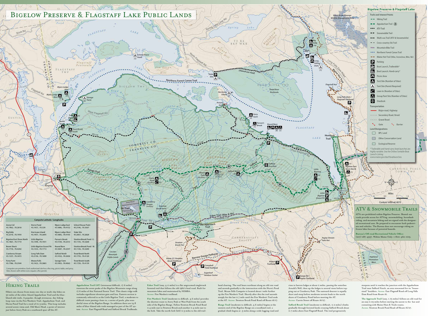
Huge shoutout to Maine’s Bureau of Parks & Lands for making such detailed and helpful maps. For a PDF version and better zooming controls, find it on maine.gov here!
Itinerary:
Day 1 (Morning): Unless you want to double your miles, convince a friend to join you and bring two cars. Drop off your terminus car at the end of the trail (Little Bigelow Trail Head Parking on E Flagstaff Rd). Then, hop in the other car (expect about an hour) and drive the scenic route to the western start of the trail on Curry Road in Stratton. Begin your trek!
Day 1 (Afternoon): Ascend Cranberry peak (2.9 miles) and stop for a lunch with a view!
Day 1 (Evening): Arrive at Horns Pond Lean-to’s (another 3.4 miles) and pass out (well, eat dinner and set up camp first).
Day 2 (Morning): Reset that circadian rhythm and rise with the sun to catch the sunrise reflecting off the pond. And if you bring your instant coffee like us, you’ll rarely have a better cup (even if the coffee itself is horrible). Eat that breakfast and get started, this is the long day - a total of 10.1 miles!
Day 2 (Afternoon): Pick your peak for lunch: West Peak (2.9 miles) or Avery Peak (another 0.4 miles). Both provide stunning vistas of Flagstaff Lake and beyond. Hike the 7ish beautiful miles to the car.
Day 2 (Evening): Don’t forget to pick up your friend’s car that you parked at the beginning of the trail, unless you left him in the dust and are ready to eat that cheeseburger (just kidding, don’t leave your friend).
Insider Tips:
We always recommend bringing a lightweight tent, but it’s possible to sleep in the lean-tos without one.
Alpine plants, including diapensia and dwarf blueberries, thrive along the rocky ridges, even late into the season.
Be prepared for gusty winds on the exposed summits—pack extra layers.
Keep your eyes peeled for both moose and bear - scat is seen quite commonly.
Tell all AT thru-hikers you encounter that you’re really tired from your 2 day trek and watch them smirk with not-so-subtle pride.
Get AllTrails+


Check out our store - this is how we fund Maine Hikes!
